Saturday, September 15, 2012

Ride the West Day 13 - Petaluma to San Francisco

Daily Statistics
Mileage:  51.28
Vertical Gain:  3312 feet
Calories Burned:  3589 (1847)

Link to Garmin Route Data

Today was a fitting end to another adventure on the bike.  Ending a terrific two weeks by crossing the Golden Gate Bridge into San Francisco was terrific.  I again spent the day riding with Gary Weinstein.  He does a great job of navigating, as well as being a terrific friend, and with many, many more turns to negotiate than normal, having him on the job kept us from ever making a bad turn.

We left Petaluma under typical cool conditions.  There is not a lot to say about the first 40 miles of the day.  It was more rolling brown California hills, with a number of stiff little climbs followed by very sweat descents.  Here I am following I believe Jeff Douglas as we are about to top one hill.  The scene is very typical of what the first miles were about.

Cresting a typical hill
One of the interesting things during the day was encountering many, many runners and vans doing a Ragnar relay out of San Francisco.  I didn't take any pictures of them, but they were spread out over miles and miles.  There were also a ton of support vans along as well.  Our SAG stop for the day was set up where we had runners coming through steadily, even though we had passed most of them well up the way.  We even found more after leaving the SAG.

We took a nice bike path for 3 or 4 miles to the outskirts of Sausalito, where Gary and I stopped at a great restaurant where we sat on the deck overlooking the harbor.  This shot pretty well captures the scene.

With Gary Weinstein at lunch in Sausalito
After lunch, we stopped across the street to where they had wooden bikes on display.  The store wasn't open, but they had some of the pieces in the window.  They use terrific craftsmanship, and the finished products were beautiful to behold.  I would love to get the chance to try one.

We then headed for the bridge.  The route sheet took us down to the water through Fort Mason for a different perspective on the bridge.  This is how it looked from down below.

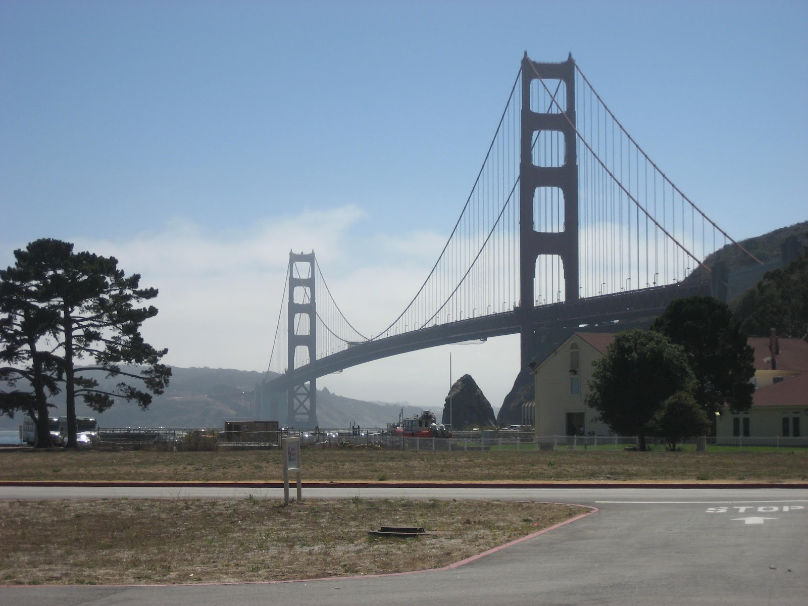
Golden Gate Bridge from Fort Mason
From this shot, we made our way under the bridge to a very steep road up to traffic level.  From there, we had to take a path under the bridge to get to the bike/pedestrian way across the bridge.  We rode across the bridge, but with all the pedestrians and other cyclists, you have to take it slow and easy.  We made out way down to the waterfront, visited a terrific sports store, and made our way to the hotel.  Here is a closing photo for the ride.

Me ready to tackle the Golden Gate Bridge
Once the luggage truck got in, I quickly showered and changed, and got back on the bike for a 3 mile ride to the ferry building to catch the bus to Emeryville and the Capitol Corridor train to Sacramento.  This is a very nice ride of almost 2 hours.  I got off the train and rode another 4 miles to my brothers for the night. 

To conclude this saga, it has been a great two weeks of riding.  The routes have not often been easy, but the scenery has been fabulous, and the opportunity to join so many of my friends from the 2010 Across America North ride made it much more special.  I will see you for my next adventure, which is as yet undetermined.

Thursday, September 13, 2012

Ride the West Day 12 - Cloverdale to Petaluma

Daily Statistics
Mileage:  70.36
Vertical Gain:  3173
Calories Burned:  4969 (2112)

Link to Garmin Route Data

Today was a very nice day and a very fun day to ride.  The route was good, and the weather was just about perfect.  We left the motel, and were quickly out on back roads in wine country.  We were on Dry Creek Road and Westside road for most of 30 miles, going past vineyard after vineyard, and winery after winery.  We were generally before tasting hours, which was probably for the best.  Here is a sample of what we saw.

Vineyard along Dry Creek Road
The grapes are ready for harvest
About 30 miles in, we entered River Road, which runs along the Russian River.  It is a good road to just work out the legs.  We had our first SAG stop at 34 miles, and were delighted that Margo Addison (a 2010 cross country rider) had given Barbara Munk brownies and strawberries to augment the usual SAG fare.  From the SAG, it was another 5 miles along River Road until we left to take the Bohemian Highway.  This was a nice wooded road taking over some hills to the town of Occidental.  I spent the whole day riding with Gary Weinstein, and here he is leading me up the Bohemian Highway.

Gary Weinstein heads up the Bohemian Highway
We stopped at a market and deli for lunch in Occidental.  In Jim Downey's honor, I had the Italian Special sub, which I am sure enhanced my performance on the way in.  About 50 miles in, we entered the Bodega Highway briefly, before some miles on Valley Ford road and highway 1.  Just over 60 miles in, we turned on to the innocuous looking Walker Road, which turned into a very nasty stretch getting over the top.  Here is Gary at the end of Walker Road, as we are getting ready to enter Pepper Road for the final stretch to Petaluma.

Gary after conquering Walker Road
The final miles to the motel were uneventful.  I was fortunate to have dinner with my second cousin Larry Olafson, but was too stupid to get a picture.  His dad is a terrific gentleman in Mountain, ND.

Tomorrow is my last day on the ride, as we make our way into San Francisco.  I will try to get a timely blog entry, but may fail, as I have some interesting logistics to handle.

Wednesday, September 12, 2012

Ride the West Day 11 - Fort Bragg to Cloverdale

Daily Statistics
Mileage:  77.32
Vertical gain:  4709 feet
Calories burned:  6409 (2730)

Link to Garmin route data

Today was a day with a lot of variety.  I think you will definitely see that as the story unfolds.  We left Fort Bragg in a thick fog, which continued while we stayed along the coast on highway 1, which was about 19 miles.  Here is a typical coastal scene in the fog.

The coast south of Ft Bragg at Little River
We left highway 1 to take California 128 the rest of the way to Cloverdale.  This immediately puts you in the Navarro River Redwoods.  I was able to ride with Jeff Douglas, Joe Schroeder, and Mark Weisbarth for a few miles in to the first SAG 27 miles in at Paul Dimmick campground.  You can get an idea of the ride from this picture of Mark from the rear.

Mark Weisbarth riding in the redwoods
About 5 or 6 miles after the SAG, we were literally out of the woods, and starting to see our first vineyards.  There is also a fruit stand (Gowan's Oak Tree)  about 40 miles in that was recommended for the apple cider.  Of course this called for a stop and some cider, which was excellent I might say.  I was there with Russ Bordeau and Mike Moseley.  This was the half way point for those doing the full 23 days, so we toasted their accomplishment with the cider.

At Gowan's Oak Tree
I mentioned we were passing through wine country, which we will do a lot more of tomorrow.  Here is a sample of what we saw.

Grapes on the vine
After the second SAG, we had to make our way over a couple of good climbs before the descent into Cloverdale.  There was also road construction in a couple of spots, requiring us to fall in behind the pilot car.  Most of us picked up a lot of asphalt grit on our tires, which stuck like crazy.  I don't think anyone had any real damage to their tires, but there was a lot of cleaning up going on at the motel.

The scenery was typical California brown hills, with a few scrub oak along the way.  It also got pretty warm on the climb, which is not my favorite.  I personally have enjoyed riding in the coastal fog.  Anyway, here is what it looks like in the California hills.

Typical California hills
The descent in to Cloverdale was fortunately uneventful, although I overshot the motel by about half a mile, before realizing I must have missed it.  I got in and had a lovely milk shake.  The good news of the day was that the climbing, while plenty, was significantly less than they had advertised.  Tomorrow will have us spending most of the day in wine country.

Tuesday, September 11, 2012

Ride the West Day 10 - Garberville to Fort Bragg

Daily Statistics
Mileage:  68.83
Vertical Gain:  5718 feet
Calories burned:  6344/2703

Link to Garmin Route Data

Today was a pretty tough day.  Lots of climbing, a little headwind, but another day of great scenery along the way.

We left Garberville, getting on and off 101 as side roads allowed.  We were on Benbow Drive for  about 4 miles, and Rte 271 for almost 6 miles.  I have borrowed the following photo from Jeff Douglas, to illustrate what the scene looked like leaving Garberville.

Jeff Douglas photo leaving Garberville
The first SAG was across the road from Standish Hickey campground at 23 miles in to the ride.  Less than two miles later, we left 101 for good as we exited on Hwy 1 for Fort Bragg.  This was also the start of our first major climb, about 4 miles at roughly 6% grade.  The good news is the weather was good, the road had minimal traffic, and the scenery was good.  Here is a view of a typical scene.

Scenery on Highway 1
Almost 46 miles in to the ride, the Pacific Ocean appeared as we descended.  The views along the coast were great.  Barbara Munk said it was the best weather along the coast since the first year they did this ride (which I think was 11 years ago).  Here is a picture of John and Chris Aylward along the coast.  They are a father/son team from back east.

John Aylward front, Chris Aylward following
Here are a couple of other scenes along the over 20 mile ride along the ocean to Fort Bragg.

Scenes along Hwy 1 coast to Fort Bragg
All in all, it was a fine, but demanding day on the road.  I will close with a photo dedicated to my Ocosta friends.  I went through the Westport they have here in California.  It advertised the best beach on the Mendocino coast.  I must say it was nice.

The Westport, California sign
Tomorrow is advertised as the biggest climbing day of the trip.  After today, I hope I have enough left to get through.  This is a pretty good bunch of riders, so they will probable do well.

Monday, September 10, 2012

Ride the West Day 9 - Eureka to Garberville

Daily Statistics
Mileage:  80.22
Vertical Gain:  4029 feet
Calories Burned:  7272 (2774)

Note:  The first number is from Garmin Connect, the second is from Strava.  I was quoting Strava only until yesterday.  I don't understand the large discrepancy.   They used to be the same.

Link to Garmin Route Data

Today was about as good as it gets.  This is my favorite day on this tour.  The Avenue of the Giants on a bicycle is absolutely terrific, as I hope you will fee after you read this.

We started out from the hotel, and made our way out of Eureka on some little used back streets.  After about 5 miles on highway 101, we got off at the College of the Redwoods exit, and made out way on some roads largely paralleling 101.  The main one was Eel River Road, with took us to the town of Loleta and Fernbridge, where we turned onto highway 211 for the trip to the SAG in the little town of Ferndale.  This is a cute little town with lots of great old houses.  I had thought we had everyone at the SAG together for the first time on this trip, until I learned that Herb got lost getting out of Eureka and put in over 6 bonus miles.  Anyway, here is a picture of the gang massed at the SAG.

S
At SAG in Ferndale
After Ferndale, the route got a little tougher, with several nasty grade hills going in to Rio Dell.  About 40 miles in to the ride, we entered the Avenue of the Giants.  This is a terrific road, even if you are in a car, but fabulous on a bike.  Here is the first touristy thing, where many of us posed in the trunk of this downed big tree.
John and Barb Solley in tree trunk
The next point of interest is this high water mark from the 1964 flood.  It is hard to describe how far above the current river level this is, or how wide the valley is at this point.  Suffice it to say it took an awful lot of water to reach this point.

Dec 1964 High Water Mark
It is hard to describe the feeling riding down the road among these huge trees.  The following picture captures it as well as I was able.

The Avenue of the Giants
The final touristy thing I had to do was go through the drive thru tree.  When I mentioned to my son Mark where I would be, he immediately asked if I would go through it.  He remembers a trip when he was about 10 when we went through in our old Toyota.  Here is the proof I did it again.

At the Drive Thru Tree
From the drive through tree, it was about 20 miles to Garberville and the hotel.  It was a steady climb for the most part, with about a 2 mile climb of some merit coming in to town.  I was trying to keep a group in sight so I wouldn't have to get my cue sheet out, and managed this modest goal.  Tomorrow we head for Fort Bragg, which is the first of two days with some serious climbing.

Sunday, September 9, 2012

Ride the West Day 8 - Crescent City to Eureka

Daily Statistics
Mileage:  83.9
Vertical Gain:  5007 feet
Calories Burned:  7132 (2992)

Link to Garmin Route Data

Today is the kind of day this ride is all about.  We had an absolutely perfect day from start to finish.  The weather was about 50 degrees and sunny as we loaded and left our home of two nights.  We very quickly got into our biggest climb of the trip so far (we topped out at about 1250 feet up, with most about 7% grade).  You can see we still had great views of the coast from this shot I took along the way.


About 15 miles in, we came to that famous tourist trap, the Trees of Mystery.  I was a little disappointed, because the last time I was there, Paul Bunyan talked with us, and I had everyone ready for it.  He was apparently off duty this time.  Here is a shot of me at Paul's foot.

Paul Bunyan and me
Our 1st SAG was a about 4 or 5 miles later.  About 5 miles after the SAG, we left 101 for the Newton B. Drury Scenic Parkway.  This is a terrific side loop of about 9 miles, with lots of big trees and minimal traffic.  Mike Munk was waiting for us at a hollowed out tree trunk, and took the following shot.  I think we had 8 or 10 of us in the shot before I left.  This is what I got on my camera.  You can check bamacyclist.com for other photos Mike takes.

Me, Russ, Mose, and Barb
I also took this shot as I rode along.  It is not very clear, but does give you an idea of the kind of riding we had in this area.

Typical of Newton B Drury Scenic Parkway
We also came across a large herd of elk as we were getting back on 101, but I couldn't get a good shot so you will have to take my word for it.  We exited 101 again, this time on Patricks Point Drivie.  Our second SAG was in the little town of Trinidad.  From there, we went on a road called Scenic Drive.  It certainly lived up to its name, but was absolutely dreadful for the quality of road.

Here is a last shot of gorgeous coastline, which I took somewhere along here.


With about 20 miles to go, they routed us on a bike path, which took us maybe 3 or 4 miles before ending on a narrow bike bridge.  We were then left to travel 2 or 3 miles on a gravel road, which did not make a lot of folks very happy.  I was fine with it, and just took it easy.  I then made it smoothly in to town and the motel.  There is a terrific old mansion, but I will leave you to look back at 2008 for a photo. 

Tomorrow is my favorite day of the ride, as we spend 30 miles in the Avenue of the Giants. 

Friday, September 7, 2012

Ride the West Day 6 - Gold Beach to Crescent City

Daily Statistics
Mileage:  61.0
Vertical Gain:  3006 feet
Calories Burned:  1863

Link to Garmin Route Data

Today was a huge success!  This is not to say we had beautiful weather, because we didn't.  When I did this trip four years ago, this day was completely socked in.  I told Mike Munk he had to make sure I could see Arch Rock.  I certainly could as the photo below will attest.  Most of the other good stuff was also very visible.

Arch Rock on right
Arch Rock is about 15 miles into the ride, after going up and over a climb of 3 miles shortly out of the motel of 4 to 6 % grade.  That is about what I like.  More, and gravity starts to win where I am concerned.  At 4 or 5 % I can go on just about as long as I need to.

Shortly after Arch Rock, I pulled off for the Natural Bridges viewpoint, and was again successful.

Natural Bridges

We then crossed the Thomas Creek bridge, which at 365 feet is the highest in the state.  I also went down a steep and wet path for Whaleshead Rock, but found it fairly disappointing.  The Rock House viewpoint had great views, but none of us could figure out what was supposed to be Rock House.  I should include a photo that is more typical of the foggy views of the day.


At any rate, we proceeded on to the town of Brookings for our SAG stop.  Barbara Munk was disappointed the bakery she had been looking forward to was closed.

About midway through the ride, we crossed the California border.  They quickly routed us off 101 onto Ocean View Drive, which made a lovely way to go.  Nice little rollers and almost no traffic are a great combination.  I stopped and had some blackberries, but they weren't as good as some I had in Oregon, so I moved on.  The scenery included farmland like this photo shows.


We continued in to Crescent City on mostly back roads.  I road the last 15 or 20 miles with Gary Weinstein, who is always very interesting company.  We have a day off tomorrow, and 5 new riders joining the group.  We lose one (Margo Addison, who is part of the North ride group).  I am not sure what I can find to do in Crescent City, so may watch a lot of football.  The rides starting Sunday are beautiful, but have a ton of climbing.

Thursday, September 6, 2012

Ride the West Day 5 - Bandon to Gold Beach

Daily Statistics
Mileage:  57.6
Vertical Gain:  2903 feet
Calories Burned:  1835

Link to Garmin Route Data

Today was another foggy day on the coast.  In spite of that, when we came to Face Rock, less than two miles into the ride, you could plainly make out the face.  I hope you can as well.

Face Rock
 We had our first SAG about 28 miles in, and were on 101 most of the way.  It was fairly easy going, and actually the cool conditions made for my kind of riding.  The SAG was at Battle Rock Historic Wayside.  In the 1850s, a Captain and 9 soldiers were kept under siege for about a week before they escaped in the dark of night.  They came back with over 70 troops and routed the Indians and set up a settlement.  Things were not always fair for the natives.  Here is Battle Rock.

Battle Rock
After a little climbing in the area of Humbug Mountain, including a nasty little section of construction, we came into the Gold Beach area on the Old Coast Road.  This is a fun little section of road, often very narrow, but very scenic.  Just as we were coming back to 101 to cross the Rogue River into town, you could see a huge number of boats.  There is apparently a derby underway, with plenty of participants.

Boats in the Rogue River
Probably the most interesting moment of the day came after we were in at the motel.  My old friend Herb Schon, now almost 81 (but with perhaps less sense than he was born with) went to the beach for a swim with Leo Anderson.  Here they both are.

Herb heads in as Leo watches
Tomorrow we cross the border in to California, with a day off planned in Crescent City. 

Wednesday, September 5, 2012

Ride the West Day 4 - Florence to Bandon

Daily statistics
Mileage:  77.8
Vertical Gain:  4322 feet
Calories Burned:  2541

Link to Garmin Route Data

I don't have a lot of nice photos to show for today.  When we got to Oregon Dunes state park, it was still completely socked in.  I didn't take a photo until we got to the first SAG, at the Umpqua River lighthouse. 

Umpqua River Lighthouse
From here, it was basically all Highway 101 for about 18 miles.  We came to a bridge coming in to North Bend, which we had been told we would have to walk the bikes over.  No sign said that, and there was a button to push to turn on warning lights that bikes were on the bridge, so I pushed the button and rode over.

Our second SAG was in the town of Charleston, where I rediscovered my friend Charlie the tuna, who was there 4 years ago.


Right after the SAG, we made a turn on Seven Devils Road.  This immediately puts you in a steep climb (I was told as much as 14%) for a mile or so.  While I was still on the steep section, I came across 3 deer, but couldn't get the camera in the proper setting fast enough, so I can't show you.  They didn't seem too worried about me.  Once you get the initial grade behind you, the next ten miles or so are fun rollers.

When I got to Bandon, I was delighted to find my room has a great view of the harbor.

View from my room at  Bandon Inn
Hopefully we will have better weather tomorrow.  We only cover 56 miles, so it shouldn't be too bad.

Tuesday, September 4, 2012

Ride the West Day 3 - Lincoln City to Florence

Daily Statistics
Mileage:  79.6
Vertical Gain:  4449 feet
Calories Burned:  2862

Link to Garmin Route Data

Today showed that we can't have perfect weather every day.  We had coastal fog virtually the entire ride, as my photos will attest.  We started out from the hotel, and I quickly got in a paceline with Joe Schroeder, Mark Weisbarth, his wife Susan Weisbarth, and myself.  We set a reasonably brisk pace until the turn off from highway 101 onto Otter Crest Loop, where we picked up a pretty good climb and the group broke up.  We came to a lovely overlook, which will feature some of the fabulous coastline.  The first is an unobstructed view, and the second includes Mark and Susan.  The Punchbowl was the site of our first SAG stop about 21 miles into the ride.  Barbara Munk and some of the folks saw a whale offshore, but I couldn't make it out.
Devil's Punchbowl at Outcropping

Mark and Susan Weisbarth at Devils Punchbowl overlook

Devil's Punchbowl
 About 6 miles later we came to the Yaquina Lighthouse, one of the oldest, or maybe the oldest in Oregon.  It doesn't have the beauty of some of the ones we will see later, but it does have history.
Yaquina Lighthouse, oldest in Oregon
 Fifty six miles in we came upon the Devil's Churn and this one (very similar) called something like Roaring Horn.  My memory isn't what it used to be.  This was shortly after the second SAG at mile 54, which was in Yachats State Park.  This was the one place the wind and fog really cut in to me, so I made it a very brief stop and got on down the road.
This is called something like Roaring Horn
 About 69 miles in, after  we had gone through a short tunnel, we should have had a nice view of the Heceta Head Lighthouse, which is very picturesque and much photographed.  Unfortunately, as the photo shows, it was much to foggy to begin to see the lighthouse.  I have included a similar view from my trip in 2008 to show what we should have seen.

View toward Heceta Head Lighthouse this year

Heceta Head Lighthouse as I saw it in 2008
I went by Sea Lion Caves without even slowing down, and made my way to town.  I was pretty tired, as I didn't really get the training in I had hoped for or need.  Today was the longest ride for me in a couple of months.

For those of you who are impatient, feel free to pull up the 2008 blog.  Sara says I am saying the same things anyway.  I am trying to include at least a little variety.  More tomorrow!

Monday, September 3, 2012

Ride the West Day 2 - Tillamook to Lincoln City

Daily Statistics
Mileage:  58.2
Vertical Gain:  4201 feet
Calories Burned:  2214

Link to Garmin Route Data

Yesterday I told you that half the riders were with me on the 2010 Across America North ride.  We had a reunion ride in Colorado last year, and we have 7 riders from that adventure here (one of the Colorado riders is the wife of an AAN rider).  We had a special jersey from that ride, and we declared today jersey day for those riders.  Here is that fine bunch.


Today was another absolutely perfect day weather wise.  We spent a good portion of the ride (about 2/3) on the Three Capes Scenic Route.  About 8 miles in, this meant a stiff climb up to the turn off for the Cape Meares lighthouse.  This is the first of what will be many, many lighthouses on this ride.  It was also advertised as the shortest lighthouse in Oregon.  It is up on a cliff, so didn't need more altitude.  It is kind of cute, so here it is.


At this stop, we also toured the Octopus Tree.  It is unknown how it got the configuration it has, but is somewhat an anomaly of nature.


Because we climb to several hundred feet above the water on several occasions, we get some great views down the coastline.  This one feature Jeff Douglas and Joe Schroeder, two of our premier riders.


Our first SAG stop was at Cape Lookout State Park, about 22 miles into the ride.  From there, the route continued through Pacific City and Neskowin (where we had our second SAG stop at 47 miles).  We had planned to head up Slab Creek Road shortly after the SAG, but the road was washed out, and specifically marked no bicycles, so we had to just continue on US 101 instead.  This cut about 5 miles out of the day, but I don't think anyone missed them.  The climb on 101 was plenty to deal with.   We arrived at our motel, the Ashley Inn & Suites in good spirits, ready for another great day tomorrow.