Thursday, September 6, 2012

Ride the West Day 5 - Bandon to Gold Beach

Daily Statistics
Mileage:  57.6
Vertical Gain:  2903 feet
Calories Burned:  1835

Link to Garmin Route Data

Today was another foggy day on the coast.  In spite of that, when we came to Face Rock, less than two miles into the ride, you could plainly make out the face.  I hope you can as well.

Face Rock
 We had our first SAG about 28 miles in, and were on 101 most of the way.  It was fairly easy going, and actually the cool conditions made for my kind of riding.  The SAG was at Battle Rock Historic Wayside.  In the 1850s, a Captain and 9 soldiers were kept under siege for about a week before they escaped in the dark of night.  They came back with over 70 troops and routed the Indians and set up a settlement.  Things were not always fair for the natives.  Here is Battle Rock.

Battle Rock
After a little climbing in the area of Humbug Mountain, including a nasty little section of construction, we came into the Gold Beach area on the Old Coast Road.  This is a fun little section of road, often very narrow, but very scenic.  Just as we were coming back to 101 to cross the Rogue River into town, you could see a huge number of boats.  There is apparently a derby underway, with plenty of participants.

Boats in the Rogue River
Probably the most interesting moment of the day came after we were in at the motel.  My old friend Herb Schon, now almost 81 (but with perhaps less sense than he was born with) went to the beach for a swim with Leo Anderson.  Here they both are.

Herb heads in as Leo watches
Tomorrow we cross the border in to California, with a day off planned in Crescent City. 

Wednesday, September 5, 2012

Ride the West Day 4 - Florence to Bandon

Daily statistics
Mileage:  77.8
Vertical Gain:  4322 feet
Calories Burned:  2541

Link to Garmin Route Data

I don't have a lot of nice photos to show for today.  When we got to Oregon Dunes state park, it was still completely socked in.  I didn't take a photo until we got to the first SAG, at the Umpqua River lighthouse. 

Umpqua River Lighthouse
From here, it was basically all Highway 101 for about 18 miles.  We came to a bridge coming in to North Bend, which we had been told we would have to walk the bikes over.  No sign said that, and there was a button to push to turn on warning lights that bikes were on the bridge, so I pushed the button and rode over.

Our second SAG was in the town of Charleston, where I rediscovered my friend Charlie the tuna, who was there 4 years ago.


Right after the SAG, we made a turn on Seven Devils Road.  This immediately puts you in a steep climb (I was told as much as 14%) for a mile or so.  While I was still on the steep section, I came across 3 deer, but couldn't get the camera in the proper setting fast enough, so I can't show you.  They didn't seem too worried about me.  Once you get the initial grade behind you, the next ten miles or so are fun rollers.

When I got to Bandon, I was delighted to find my room has a great view of the harbor.

View from my room at  Bandon Inn
Hopefully we will have better weather tomorrow.  We only cover 56 miles, so it shouldn't be too bad.

Tuesday, September 4, 2012

Ride the West Day 3 - Lincoln City to Florence

Daily Statistics
Mileage:  79.6
Vertical Gain:  4449 feet
Calories Burned:  2862

Link to Garmin Route Data

Today showed that we can't have perfect weather every day.  We had coastal fog virtually the entire ride, as my photos will attest.  We started out from the hotel, and I quickly got in a paceline with Joe Schroeder, Mark Weisbarth, his wife Susan Weisbarth, and myself.  We set a reasonably brisk pace until the turn off from highway 101 onto Otter Crest Loop, where we picked up a pretty good climb and the group broke up.  We came to a lovely overlook, which will feature some of the fabulous coastline.  The first is an unobstructed view, and the second includes Mark and Susan.  The Punchbowl was the site of our first SAG stop about 21 miles into the ride.  Barbara Munk and some of the folks saw a whale offshore, but I couldn't make it out.
Devil's Punchbowl at Outcropping

Mark and Susan Weisbarth at Devils Punchbowl overlook

Devil's Punchbowl
 About 6 miles later we came to the Yaquina Lighthouse, one of the oldest, or maybe the oldest in Oregon.  It doesn't have the beauty of some of the ones we will see later, but it does have history.
Yaquina Lighthouse, oldest in Oregon
 Fifty six miles in we came upon the Devil's Churn and this one (very similar) called something like Roaring Horn.  My memory isn't what it used to be.  This was shortly after the second SAG at mile 54, which was in Yachats State Park.  This was the one place the wind and fog really cut in to me, so I made it a very brief stop and got on down the road.
This is called something like Roaring Horn
 About 69 miles in, after  we had gone through a short tunnel, we should have had a nice view of the Heceta Head Lighthouse, which is very picturesque and much photographed.  Unfortunately, as the photo shows, it was much to foggy to begin to see the lighthouse.  I have included a similar view from my trip in 2008 to show what we should have seen.

View toward Heceta Head Lighthouse this year

Heceta Head Lighthouse as I saw it in 2008
I went by Sea Lion Caves without even slowing down, and made my way to town.  I was pretty tired, as I didn't really get the training in I had hoped for or need.  Today was the longest ride for me in a couple of months.

For those of you who are impatient, feel free to pull up the 2008 blog.  Sara says I am saying the same things anyway.  I am trying to include at least a little variety.  More tomorrow!

Monday, September 3, 2012

Ride the West Day 2 - Tillamook to Lincoln City

Daily Statistics
Mileage:  58.2
Vertical Gain:  4201 feet
Calories Burned:  2214

Link to Garmin Route Data

Yesterday I told you that half the riders were with me on the 2010 Across America North ride.  We had a reunion ride in Colorado last year, and we have 7 riders from that adventure here (one of the Colorado riders is the wife of an AAN rider).  We had a special jersey from that ride, and we declared today jersey day for those riders.  Here is that fine bunch.


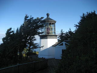
Today was another absolutely perfect day weather wise.  We spent a good portion of the ride (about 2/3) on the Three Capes Scenic Route.  About 8 miles in, this meant a stiff climb up to the turn off for the Cape Meares lighthouse.  This is the first of what will be many, many lighthouses on this ride.  It was also advertised as the shortest lighthouse in Oregon.  It is up on a cliff, so didn't need more altitude.  It is kind of cute, so here it is.


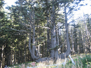
At this stop, we also toured the Octopus Tree.  It is unknown how it got the configuration it has, but is somewhat an anomaly of nature.


Because we climb to several hundred feet above the water on several occasions, we get some great views down the coastline.  This one feature Jeff Douglas and Joe Schroeder, two of our premier riders.


Our first SAG stop was at Cape Lookout State Park, about 22 miles into the ride.  From there, the route continued through Pacific City and Neskowin (where we had our second SAG stop at 47 miles).  We had planned to head up Slab Creek Road shortly after the SAG, but the road was washed out, and specifically marked no bicycles, so we had to just continue on US 101 instead.  This cut about 5 miles out of the day, but I don't think anyone missed them.  The climb on 101 was plenty to deal with.   We arrived at our motel, the Ashley Inn & Suites in good spirits, ready for another great day tomorrow.

Sunday, September 2, 2012

Ride the West Day 1 - Astoria to Tillamook

Days Statistics
Mileage: 67.8
Vertical Gain:  3947 feet
Calories Burned:  2306

Link to Garmin Data

Today started another new adventure on the bicycle.  I will be bicycling from Astoria, OR to San Francisco, CA over the next two weeks.  One of the neat things about this ride is that half the riders were on Across America North with me in 2010.  The photo below shows this group of alumni from 2010.  We are all very excited and please to be on the road together again.  This is a repeat for me of a ride I did in 2008 (when I did the whole thing down to Costa Mesa).  This time I am settling for the first two legs.


We got off to a nice start on a beautiful day.  It was probably low 50s at the start, and low 70s at the finish.  One of the first stops was in Seaside, where we found the Lewis and Clark statue as we reached the beach.  The building in the background, interestingly enough, is where I will spend Christmas with my brother, sister, and kids/grandkids.  My brother, the king of timeshares, has arranged a beautiful suite there.


The views along the beach are terrific.  This is haystack rock, one of the more photographed rocks along the way.  

Another fun thing in this part of the country is the chain saw art that you will find.  I stopped and took a shot of this one.


Unfortunately, the battery in my camera died before I had taken all the shots I wanted.  I will do better tomorrow.  We went through a number of cute little towns (including Cannon Beach, Manzanita, Nehalem, Wheeler, Rockaway Beach, Garabaldi).  Gary and I stopped at a small town carnival in Rockaway Beach.  It was most interesting.  I took a couple of shots at the folks in the dunk tub, but my arms were too tight from riding, and I wasn't even close.  We also toured the Tillamook Cheese Factory when we got to town.


Overall, this looks like it will be a fun ride, with lots of great old timers, and a good mix of new folks.  My old buddy Herb Schon, now over 80, is also along for the trip.

Monday, August 9, 2010

AAN Day 50 - Manchester to Portsmouth, NH

Daily Statistics: Mileage: 61.4 miles Average Speed: 14.1 mph
Vertical: 2517 feet Depart: 6:36 AM Arrive: 1:27 PM
Calories: 4068


Link to Garmin ROUTE DATA

Today was all about a group celebration of a common achievement than about the route or the ride. For the record, it was a perfect day to ride. The weather was probably mid 60s to start, and I don't think it ever got above 80. The route was along lovely tree lined roads and quiet residential neighborhoods, but this was not the focus.
As this first picture shows, virtually the entire group was together for at least a while at the only SAG. Everyone wanted to share in the joint feeling of achievement, and of course, what have become good friends will be going their separate ways.

About 10 miles down the road, we came across a bakery, and again, almost everyone stopped to share the experience with coffee and pastry. We sat outside on the patio and chatted. We had been given a target to be at Rye Middle School no later than 11:30, so we couldn't stay indefinitely. It was still about 11 or 12 miles from the bakery to the middle school.

Once at the middle school, once everyone was accounted for, we assembled for our final group photo. You can see the handsome bunch below.

Of course, once a photo had been taken with virtually everyone's camera, it was off to Rye's Wallis Sands Beach for the final festivities. Here you can see me making the ceremonial dip of the front wheel in the Atlantic. It was a festive occasion.

Once again I was fortunate to have friends in the area. My old friend Doug Joyce and his wife Phyllis, who live in Stratham, NH came down to the beach to greet me at the finish. They are pictured here with Leo and Sue Anderson, who they quickly found had a common interest in sailing. Doug and Phyllis were kind enough to give me a first class tour of the area and a fine dinner on the water to cap the adventure.

Of course, I had to make my way back to the hotel after the festivities at the beach, and couldn't resist a quick side trip across the bridge to Maine, to add one more state to the trip. I stayed about 1 minute, and got back and boxed my bike and showered to be ready for Doug and Phyllis.

This brings us to the end of another wonderful ride. I hope those of you who have been with me through this blog have enjoyed the journey. I can't tell you how much fun it is to make the trip, and what a sense of accomplishment comes from its completion. If you enjoyed the ride, drop me an email to let me know.

Sunday, August 8, 2010

AAN Day 49 - Brattleboro, VT to Manchester, NH

Daily Statistics:
Mileage: 79.4 miles Average Speed: 14.4 mph
Vertical: 5114 feet Depart: 7:03 AM Arrive: 12:59 PM
Calories: 5808

Link to Garmin ROUTE DATA

Today was a beautiful day on the road, but it wasn't real easy. As you can see from the stats, we had a lot of climbing again today, and my legs hadn't really recovered from yesterdays work. We did have ideal conditions, as it was a beautiful clear day, with temps about mid 50s at departure, and high 70s at completion.
About a mile out of the motel, we came to the New Hampshire border, where I took the obligatory welcome to picture. This is the 10th state (11 if you count Ontario) we cross in our trek across the country, and for me, it will be the final. Last time I crossed, I made the short ride across the border into Maine, but I don't feel the need to do so this time, as that square has already been checked.
We were in Keene about 15 miles into the ride. I thought this United Church of Christ was a lovely picture on the center square of town. New England is full of these picturesque old churches.
While we spent much of the day on NH 9 and 31, we did get on a number of back roads as well. Here is a picture I took on Old Concord Road out of Keene. You can see it is nicely wooded and very green. It is also a tough little climb. You can also notice there is little to no traffic.

Here is another example of a New England church, taken I believe in Bennington (NH this time, yesterday it was Bennington, VT). I could have shot a bunch more of these, as I find them very interesting. I just realized this one was actually across from the second SAG in Francestown.
From the second SAG, we continued on Rt 136 to Rt 13. At 65 miles into the ride, we turned on Meadow Road to make our way to the infamous Joe English road. This is a very steep road, with grades in excess of 20% in spots. Three years ago I rode straight up it, but this time I had to do a little serpentine action. I must be getting old.


I joined up with Mark Weisbarth about this time, and we rode the rest of the way in together. He was a little nervous in spots, because neither Meadow Road or McCurdy Road had street signs, and he wanted to be sure we were on the route. I pressed on fearlessly, and it all worked out. We made our way into town to the Comfort Inn, and I immediately proceeded across the street to Subway for lunch. We have our farewell banquet this evening. It should be fun, but can be a little long, as everyone will say a little something, the staff will make presentations, etc.
I tell people tomorrow will be like the ride into Paris on the Tour de France. A lot of celebrating the end of a long journey. The finish at the beach is great, however.